From the Field: The Inuvik-Tuktoyaktuk Highway
Case Study
Canada’s north is famous for its extreme environment and the stories it spawns. For E. Grubens Transport and Inukshuk Geomatics, an aboriginal majority-owned partnership between the Inuvialuit Development Corporation and Challenger Geomatics Ltd., building the most northerly 60 kilometres of the 120-kilometre Inuvik-Tuktoyaktuk highway gives rise to its own stories.
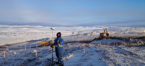
“It’s like building a road on the back of a serpent,” says James Lay, Vice President of E. Grubens, the main contractor for the highway’s construction. That’s because when the permafrost thaws in the summer, it heaves, causing the survey control points that the surveyors pounded into the ground, to shift. These have to be checked and recalibrated each year to keep the alignment true.
Inukshuk/Challenger provided survey and geomatics support including the original ground survey for the highway’s design; identifying routes to gravel pits and measuring the amount of gravel taken; guiding all aspects of the construction; undertaking the largest legal land survey done on Canada Lands in 2017, and the final as-built survey.
The job took four years. Even up to a couple of weeks before the official opening of the highway on November 15, 2017, surveyors were establishing the final as-built stakes.
The crew included three to four people working from the Inukshuk/Challenger Calgary or Whitehorse office, managing and analyzing data; and 12 to 15 surveyors and technologists working in the field. Generally, only one or two surveyors worked at one time. Their job was tough.
The Work
At the beginning, Inukshuk/Challenger surveyors walked through open fields to pinpoint gravel pit locations and establish control points for the highway’s footprint, guiding the entire project. In the summer their scouting took them across wet and muddy terrain, with hummocks and low lying shrubs that made walking difficult. They pounded metal monument stakes into the frozen ground, rechecking those control points as the permafrost changed their position. Then wooden construction stakes were placed every 20 metres; they were constantly destroyed by the big equipment and needed to be replaced frequently.
“It was a 24/7 operation, with 40 pieces of very expensive equipment going continually,” Lay says. “The surveyors out in front can’t stop or they will hold up everything; it’s like a train coming through.” He adds “They’ve gone beyond their call of duty into difficult analysis on this very unusual road that was moving all the time.”
Most of the work was done in 24-hour-a-day darkness, with temperatures dipping to -52°C and a fierce wind. Solar flares that cause the Arctic’s northern lights can also wreak havoc with the survey instruments. During early pioneering of the gravel sources and the highway’s right-of-way, the workers’ portable camp, comprising of several trailers, was dragged on skids behind bulldozers to a new location every 10 kilometres.
To make their job more efficient, Inukshuk/Challenger introduced E. Grubens to GPS technology, installed in the spread caterpillars allowing the operators to see from their cabs what the surveyors see on the ground. Inukshuk/Challenger technologists helped set up the equipment.
“Using these new technologies made our work more productive,” says Val Petushkov, Project Manager. “It’s our professional duty to educate our clients about available new technology that will make their construction process more efficient.”
The Benefits
The idea of an Inuvik-Tuktoyaktuk highway started with John Diefenbaker’s government in the 1960s, which recognized that the north and, in particular, Tuktoyaktuk would benefit enormously from having a year-round highway to replace the seasonal ice road.
It means that supplies can be hauled into the community less expensively by road than being shipped by barge or flown in. Residents won’t have to take expensive flights to connect with the south.
“The highway gives us a whole new perspective,” says Denny Rodgers, former Mayor of Inuvik and General Manager of the Inuvialiut Development Corporation, the majority stakeholder in Inukshuk. “It could be for the development of the north, what the railway was for the west. It employs locals to build and maintain it and opens up tourism. Tukoyaktuk will be connected to Inuvik, the Dempster Highway to Whitehorse, and the rest of world. It’s also important to Canada, because we can open up the region’s untapped resources.”

