Bathymetric Survey in Northern Hudson’s Bay
High-Resolution Mapping Completed in Northern Hudson’s Bay
Mapping the ocean floor takes grit, skill, and a team that refuses to back down from tough conditions. This summer, our hydrographic survey crew spent more than 40 days aboard the Fundy Legend completing a high-resolution bathymetric survey in the remote northern reaches of Hudson’s Bay.
Our Sub-Arctic team overcame cold winds, tight vessel space, and demanding equipment logistics to deliver detailed seafloor data that will support navigation and future scientific research in one of Canada’s most rugged marine environments.

Advanced Technology Drives Reliable Mapping
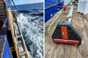
Northern work is unforgiving, and the technology needs to match the challenge. The team relied on a Kongsberg EM-2040 multibeam sonar system, paired with frequent Sound Velocity Profiles collected using a Valeport probe. Continuous data monitoring and early-stage quality checks were carried out in CARIS HIPS and SIPS, keeping the dataset clean and dependable from day one.

Technical Calibration and Setup
Before operations began, the hydrographic system went through a full calibration sequence. This included a patch test, critical for confirming pitch, roll, and yaw offsets and ensuring the sonar performed accurately in the ever-changing conditions of Hudson’s Bay.
Challenging Field Conditions
Working from a compact vessel demands constant cooperation and adaptability. Limited living quarters, constrained storage, and complex cable routing made mobilization demanding. When conditions test our patience, our creativity, and our ability to look out for your team are the working environments where Challenger thrives

Looking Ahead
Each northern project sharpens our approach and our experience. This mission highlighted the value of:
-
Earlier mobilization
-
More frequent crew rotations
-
Larger vessels for extended offshore operations
These experiences help us refine our methods and continue delivering dependable data in some of Canada’s most challenging waters.
The crew lived up to the Challenger name with their innovation, commitment, and ability to push through whatever is thrown our way. Their work contributes to safer navigation, deeper scientific understanding, and a stronger foundation for future projects in Hudson’s Bay.
Challenger is built for this work, and we’re excited for more.
