City of Calgary Flood Aerial Survey
City of Calgary
Project Summary
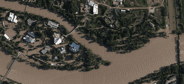
During and immediately after the 2013 Flood, Challenger provided digital aerial survey and mapping support for the City of Calgary. Included data collection for shoreline features along the Elbow River and Bow River water edges.
Services Delivered
- Surveying and Mapping Services
- Air photo acquisition flight plan
- Air photo acquisition at 10cm Ground Sample Spacing by using photogrammetric Digital Camera Ultra CAM Eagle
- Ground Controls planning
- Aerial Triangulation and Bundle Adjustment
- Photogrammetry shorelines collection from stereos
- Ortho and Mosaic for Flood and post-Flood photos.