After consulting with you to determine the specific needs of your project, Challenger can capture spatial and other data for your project using a wide variety of remote sensing technology:
Virtual Project Access
Bring your project to you using Challenger’s spatial tools
Bring your project to you using Challenger’s spatial tools
Access critical data on your project with our remote sensing and visualization solutions
Challenger has various remote sensing and visualization tools that can help your team keep projects moving forward when travel and on-site visits are not possible. We can provide you with the critical spatial data necessary for design and engineering work to continue, or even a digital model of your project to enable virtual visits and other planning to go on. In many cases, new data collection is not even necessary – Challenger has access to extensive data that you may not even know exists.
After consulting with you to determine the specific needs of your project, Challenger can capture spatial and other data for your project using a wide variety of remote sensing technology.
Enhanced Experience for Energy Projects
Enhanced Experience for Energy Projects
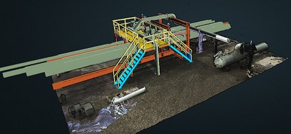
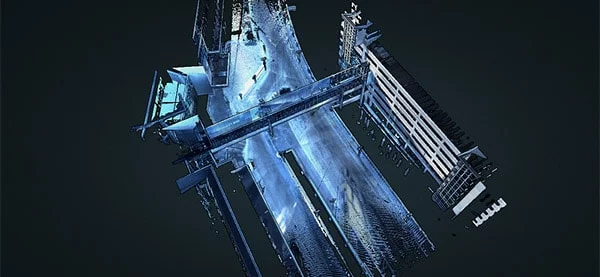
Pipeline Corridor Survey
Challenger has completed numerous scanning projects, acquiring detailed terrestrial LiDAR data from Alberta pipeline corridors.
This 3D model of the above-ground structures is accurate to within 3mm. Models can be used to isolate individual objects or layers. Products can be delivered as a mesh wireframe or a fully rendered point cloud in both cloud and export formats.
These models allow clients to take measurements and make the calculations necessary for engineering design and collision detection.
To access an online 3D viewer that allows you to pan, rotate, zoom, and more within a sample 3D point cloud, please click on the button below.
View and Manipulate a Sample 3D Data Set
(Note that the sample data set must be opened using Chrome or Firefox; Explorer or Edge are not supported)
Enhanced Experience for Construction Projects
Enhanced Experience for Construction Projects
Airport Construction and As-Built
Using Leica Geosystems P40 High-Definition Laser Scanners, Challenger collected as-built data at multiple construction sites as part of the Calgary International Airport Development Program.
The multi-billion-dollar program included construction of a new international terminal, new parallel runway, enhanced baggage handling system, and other improvement projects.
The as-built data provides a detailed record of the completed construction work and can be compared to design drawings to ensure compliance.
To access an online 3D viewer that allows you to pan, rotate, zoom, and more within a sample 3D point cloud, please click on the button below.
View and Manipulate a Sample 3D Data Set
(Note that the sample data set must be opened using Chrome or Firefox; Explorer or Edge are not supported)
Enhanced Experience for Engineering Projects
Enhanced Experience for Engineering Projects
Road and Slope Monitoring
Challenger collected UAV-based aerial imagery and spatial data as part of a deformation monitoring project, which included a test cut and large road fill.
The data was collected using quadcopter UAVs and high precision GPS.
This work supported site analysis for future earthworks and risk management.
The point cloud model generated enabled our client to effectively analyze the slope and extent of instability.
To access an online 3D viewer that allows you to pan, rotate, zoom, and more within a sample 3D point cloud, please click on the button below.
View and Manipulate a Sample 3D Data Set
(Note that the sample data set must be opened using Chrome or Firefox; Explorer or Edge are not supported)


Side Scan Sonar

Piperack - 3D Model

Bathymetry Survey - Pipeline Crossing

Bare Earth LiDAR

3D Scout Tool

3D Point Cloud Web Viewer

Molson Brewery - Heritage Preservation

F.H. Collins School - UAV Flythrough

YYC Airport Pedestrian Walkway - TruView Point Cloud

Faro Mine - Slope Monitoring
Project Data Acquisition

Unmanned Aerial Vehicles (UAVs)
Challenger has an extensive fleet of fixed-wing and quadcopter UAVs that are ideal for acquiring highly detailed data and imagery to support planning and monitoring for small to medium projects. The imagery collected using UAVs can be used for building high resolution, spatially correct orthomosaics and 3D models.
Aerial Orthophotography
Fixed-wing platforms equipped with advanced orthophotography camera systems are ideal for acquiring accurate and detailed data and imagery to support planning and monitoring, for larger areas or remote project sites that are difficult to access.
Satellite Imagery
Challenger has reseller agreements in place with several of the world’s leading satellite imagery providers, and can quickly acquire cost-effective data and imagery to support planning and monitoring, for very large or remote project sites that are difficult to access. Suitable existing archival imagery may be readily available, or satellites can be tasked for specific needs within a few weeks.
High-Definition Laser Scanning
Challenger as a variety of survey-grade High Definition Laser Scanning instruments that are ideal for acquiring extremely accurate and detailed LiDAR data and imagery to support design and engineering, for small to medium projects such as facilities, plants, etc.