Clearwater Oil Sands Pilot Project
Alberta Oil Sands
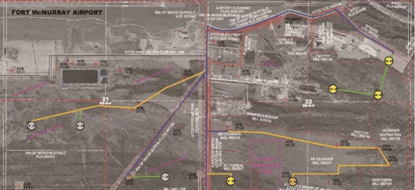
Project Summary
The Clearwater oil sands pilot project is located approximately one mile southeast of the Fort McMurray Regional Airport. Challenger provided survey and mapping support to define and assess oil sands resources and related infrastructure.
Services Delivered
- Surveying and Mapping Services
- Aerial Photo acquisition & orthophoto production
- Mapping for OSS, CPP and Annual Reports
- Corehole surveys
- Disposition surveys for camp, wells, lay down sites,
- Desk top study for placement of pilot plant.
- Mapping support for Pilot project regulatory application.
- LiDAR acquisition.
- Comprehensive mapping using LiDAR, orthophoto and disposition mapping