Canopy Cover Analysis
City of Edmonton
Project Summary
This project involves the use of existing City of Edmonton remote sensing and landscape feature datasets to analyze the canopy cover of Edmonton’s urban forest. The project also included program development for future years’ canopy analysis.
Services Delivered
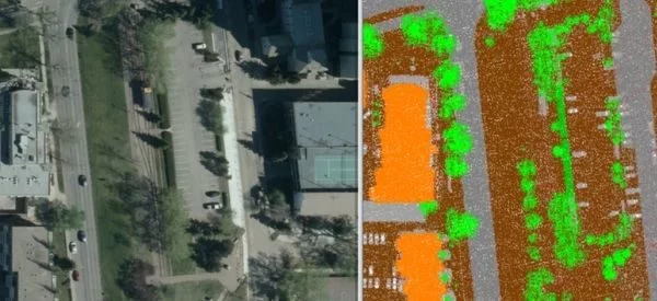
- Complete urban canopy cover analysis of the City of Edmonton using the City’s 2019 Airborne LiDAR point cloud LAS file data and 4 band imagery
- High resolution (25 pnts/m2) LiDAR tree classifications to tree deciduous, tree coniferous, shrub deciduous, shrub coniferous, and grass.
- Program development to automatically interpret and analyze canopy data. Identified individual trees and calculated canopy cover percentages over the natural area and naturized area. Also, we performed canopy cover analysis of ornamental trees, and of each of the five classes mentioned above.
- Analysis was based on an existing city dataset, and Spring 2019 10cm Air Photo and Summer 2019 High-Density LiDAR data